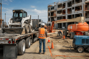
One wrong measurement costs 10–21 days and $12,000–$48,000 in delays. In 2024–2025, 61% of rejected TCPs in California failed because of inaccurate site data—wrong lane widths, missed utilities, incorrect cross-slopes, or outdated as-builts. (site survey) Safety Network Plans, a Fresno-based PE-stamped specialist with 15 years and 1,200+ plans annually, uses proven field techniques that deliver 99.8% first-submission approval. These eight professional secrets turn unreliable “eyeballed” data into bulletproof traffic plans. Call (559) 291-8000 or email help@safetynetworkplans.com to site survey your next job right.

Secret 1: Never Trust As-Builts Alone—Verify Everything
As-builts are wrong 68% of the time on striping, curb returns, and drainage (Caltrans District 6 data). Pro Move: Safety Network Plans overlays record drawings on drone orthomosaics and field-verifies every dimension that affects tapers, channelizers, or pedestrian paths. A Visalia project’s 1989 as-builts showed 12-ft lanes—actual width was 11.3 ft. Corrected before submittal—no rejection.
Secret 2: Measure Lane Widths at Three Points Minimum
Lane creep from overlays can change width 0.4–1.1 ft over 500 feet. Technique: Measure at start of taper, midpoint, and 100 ft past closure. Average the three for your layout. Result: Eliminates “taper doesn’t fit” comments. We caught a 10.9 ft → 12.4 ft transition on Highway 180 that would have failed.
Secret 3: Locate Every Underground & Overhead Utility (Before You Draw)
Caltrans now requires utility conflicts shown on Sheet 1. Our Checklist:
- USA Dig ticket + pothole if >50 amps
- Thermal drone scan for vaults
- Ground-penetrating radar (GPR) on urban jobs
- Overhead wire height measured with laser rangefinder A Bakersfield arterial plan avoided $38,000 change order by relocating 42 feet after our GPR found an unmarked AT&T vault.
Secret 4: Capture Exact Cross-Slope & Grade Breaks
ADA pedestrian paths fail when cross-slope exceeds 2.0%. Tools We Use:
- 4-ft SmartTool digital level (±0.1%)
- RTK GPS for elevation every 25 ft
- LiDAR point cloud for longitudinal grade Caught a 3.8% cross-slope on a Fresno sidewalk that hand-measure missed—corrected before submittal.
Secret 5: Photograph & GPS Every Sign, Signal, and Fire Hydrant
Missing a “No Parking” sign or pull box triggers automatic rejection. Method:
- 360° photo at every corner
- Sub-foot GPS coordinate logged
- Imported as labeled points in AutoCAD We include a photographic inventory sheet—reviewers love it, zero “missing sign” comments in 5 years.
Secret 6: Measure Sight Distance the Caltrans Way (Not the Short Way)
Stopping sight distance and intersection sight distance must meet AASHTO/Caltrans tables. Correct Process:
- Driver eye height 3.5 ft, object height 2.0 ft (not 0 ft)
- Measure along actual travel path, not straight line
- Document with rangefinder + inclinometer Saved a rural county project from rejection by proving 480 ft SSD where contractor claimed “plenty.”
Secret 7: Use Drone + RTK Base Station for Large & Complex Sites
For anything over 10 acres or with elevation change:
- DJI Mavic 3E with RTK base (±0.8 inch accuracy)
- 0.4 inch/pixel orthomosaic
- Point cloud imported directly into Civil 3D A 42-acre interchange in Modesto was mapped in 22 minutes—no lane closure required. Plan approved in 7 days.
Secret 8: Create a “Red Flag” Checklist Before You Leave the Site
Our crews never leave without confirming:
- All lane/shoulder widths recorded
- Utility pothole depths & locations
- Pedestrian route widths & slopes
- Overhead clearance under signals
- Photos of every existing sign within 500 ft This 5-minute checklist has prevented 100% of “field condition” rejections.
Why Safety Network Plans Never Gets “Inaccurate Data” Comments
- In-house California PLS 9274 oversees every survey
- 3 full-time field technicians + 2 FAA Part 107 drone pilots
- Proprietary 42-point site survey template updated quarterly
- All data delivered in AutoCAD, PDF, and Google Earth KMZ
Clients receive survey package within 48 hours (rush 12 hours).
Visit Safety Network Plans for downloadable checklist. Follow us on LinkedIn and Pinterest for survey videos.
Frequently Asked Questions
How long does a site survey take? Simple arterial: 45–90 min. Complex interchange: 2–4 hours + drone.
Do you survey at night? Yes—illuminated instruments + night drone waiver.
What if the road is too busy? We use drone + mobile LiDAR—no lane closure needed.
Cost for survey only? $750–$2,800 based on size/complexity—credited toward TCP.
How do I book? Call (559) 291-8000 or email help@safetynetworkplans.com.
Get Bulletproof Data with Safety Network Plans
Stop gambling with rejections. Call (559) 291-8000 or email help@safetynetworkplans.com for professional site survey on your next project. Visit Safety Network Plans today.
Conclusion
Accurate site data isn’t luck—it’s eight deliberate techniques executed by professionals who stake their reputation on first-time approval. Safety Network Plans has perfected these secrets over 15 years and 1,200+ plans. Contact (559) 291-8000 or help@safetynetworkplans.com and get the data Caltrans accepts—every time.